Close
Faqja 249 prej 255 FillimFillim ... 149199239247248249250251 ... FunditFundit
Duke shfaqur rezultatin 2,481 deri 2,490 prej 2545
  1. #2481
    me 40 hajdutë Maska e alibaba
    Anëtarësuar
    12-12-2005
    Vendndodhja
    Ne shpellen e pirateve
    Postime
    5,671
    The sea on the western side, Taras (Taranto), today’s Gulf of Taranto, is named in Greek. But the rest of the map is in Messapian, the ancient tongue of the local tribes, although the script is ancient Greek.
    Deti në anën perëndimore, Taras, Gjiri i sotëm i Tarantos, është emëruar në Helenishte. Por gjithë emrat tjerë në hartë janë në gjuhën Mesape, gjuha e lashtë e fiseve vendase, ndërsa shkronjat janë helene.

    Kjo është çfarë shkruan aty.

  2. #2482
    Restaurator Orbis Maska e Baptist
    Anëtarësuar
    20-11-2004
    Postime
    8,690
    Citim Postuar më parë nga Baptist Lexo Postimin
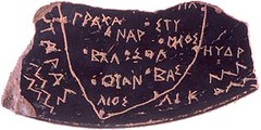
    Kjo gjetje [qe do te kete kene tjegull rrethore prej se ciles na eshte ruajtur vetem rretrh 1/6 e permbajtjes se saj] ka nje shkrim nga me interesantet qe kam pare ndonjehere, ne fakt:
    -ajo qe dalloj une eshte se inkripcioni i realizuar me gerrithje nuk eshte nje shkrim futja koti si jemi mesuar te shohim, eshte dicka me speciale:
    .:: Kjo eshte harte gjeografike e Mesalplikut ::.
    Nga krahu i djathte mund te lexojme HYDR / I;
    Shenim i cili mund te mund te tregoje edhe emrin e Detit Adriatik ne nje forme te vjeter origjiale Hydri.
    Dhe nese e teprojme eshte e mundur qe edhe pjeset tjera te glosave qe gjinden ne hapesiren e detit te anes se djathte te jete Hydrili[?r/k]. Por, kjo eshte pak e mundur. Per t'i dhene emrin Adriatikut mjafton edhe hydria burimore.

    Por, duke qene se kemi nje pikeshenim ne cep te kufirit te ketij bregu prane emrit, bejet e qarte se eshte fjala per nje vendbanim me emrin HYDR-a, kuptimi i se ciles duhet te jete: "hyrja", "moli", apo ajo qe eshte bere me e perditshme tek perdoret; Porti.

    Per me shume, - kemi dhe qytetin qe mban kete emer te regjistruar prej shekujsh, e qe ne kohen romake i takonte Prvinces Kalabreze; me po kete emer: Hydr-us; Hydr-untum. Ky port mendohet te kete qene me 'i rendesishem' se porti i Brund-isit, (nje emer tjeter Messap te cilit ndodhe se i kthehemi me vone) sepse ishte me afer Apollonise e cila dikur lidhte me tregjet e Lindjes.

    Me poshte dhe pak me ne ball me portin e Durresit, kemi portin tjeter me vendin ose qytetin LI[K/R]? (Per mua momentalisht i panjohur). Tutje ne maje drejt korkyres kemi vendbanimin/themelaten LIOS. Siper kemi vendin: OTAN ose KUTAN . Siper tij kemi: BAL ose B[EShE]L; SOL [sethel]; MKOS, (?MIOS); STY, [EShTI]; anash: Qytetin e fotrtifikuar NAR dhe portin tjeter majtas: ? GRAkHA.

    Ne krahun e majte mund te shohim detin tjeter me shkronja mire te lexueshme:
    [O/U]TARAS; ku lehtesisht pernjohim emrin Otranto ose, edhe, Taranto, -shkronja e pare duhet te jete O/U pavaresisht a i perket pjeses tjeter te emrit: U-TARAS; qe me kete U semantike mund te kete dhene kuptim te brendesise; nje hapesire te brendshme. I cili lehtesisht mund te kete qene emer alternativ per kuptimin e fjales dhe emrit tjeter koekzistent BRENTION (Brendësi), sado qe eshte mjafte e pranueshme edhe zgjidhja Briri ,marre parasysh se sot ajo qe quhet Brindisi gjndet ne bregun e jashtem te Utres apo tarantit, dhe qe e ben me te besueshem kuptimin nga rrenja tashme gjersisht e pranuar shqipe: BRIN-DI-SI.

    Emri Messapi (ku "s" e dyte sherben si vize ndarese ne emerformim) do te thote me nje fjale Mesdeteve, apo me burimisht: Mesujerave; kuprim te cilit kontribon edhe emri krahinor Apulia; [ab-Ujia].
    Emri i tjeter prane seKALABRIA, e cila gjithesesi mund te kete qene formuar nga shprehja tashme e humbur (ne shumicen e arealit shqipfoles) por por qe shumica ende e mbajne mend te pashkdyzuar per teformuar fjale tjera: KALA~, qe shenjon dicka te lidhur bashk; te nderlidhur. Te varur ne nje trup, dege, nje fije, pergjithesisht: ne nje pike te perbashket, dhe e cila i bashkon. Ky eshte kuptimi i parafjales KALA (te dy a-te e shkrurtera, me theksin e shkurte te rrokjes se pare). Pjesa tjeter e fjales eshte serish e pernjohshme nga shqipja BRI qe e ndeshem edhe te toponimi Brindisi.

    Brindisi - sipas Piri Reisit, shek. XVI.
    Emer qe gjithesesi mund t'i kete pasur te dy kuptimet e gjuhes shqipe, edhe "brendesi" edhe "brindyshi".
    b.b. Troy III p.a.e.
    ( kerkoj ndjese ngase padashje me qenka aktivizuar "overwrite" komanda dhe me qelim plotesimi e korrektimi te disa fjalive, njekohesisht i paskam gjymtuar ato, - permbajtja e te cilave tani me nuk me kujtohet )


    Fatkeqsisht me duhet ta deshproj pak veten per t'ua bere te ditur dhe nje here se nuk ka asnje dyshim se ajo cope tjegulle nuk eshte harte. Vetem se me vjen keq qe nuk e kam mundesine ta shoh 3-4 vjet me pare...,
    gjetesit qe e mbajten te fshehte ta greqizonin interpretimin e saj duke i hequr cdo lloj merite ilire. Por kjo nuk eshte e tera. Armiqte vullnetar nuk u mjaftuan me kaq: Kriminelet ne fakt, -thyen, asgjesuan dhe zhduken mbi 1/6 e diskut te vogel, qe sic arrij te konkludoj ishte per perdorim personal dhe mund ta mbaje kudo me vete.


    Siperfaqja e thyerjes eshte e fresket!
    Terrakota per dallim nga ana e siperfaqes se lemute dhe te pjekur, nga anet e thyera terheq papastertine e vendit permes lageshtise dhe efektit kapilar brenda ne strukture dhe eshte pothuaj e pamundur te lahet, ashtu qe te duket sikur eshte thyer sot.

    Asgjesimi i faktografise se kultures se larte ilire vazhdon edhe ne shekullin XXI me intenzitet te pa shuar.
    Aeneas Dardanus
    Lavdi, pasthirrme fosilesh, germadhash e rrenojash vershelluese. -Eja pas meje!...

  3. #2483
    Restaurator Orbis Maska e Baptist
    Anëtarësuar
    20-11-2004
    Postime
    8,690
    By Hilary Clarke in Rome
    Last Updated: 12:33AM GMT 19 Nov 2005

    The map details the Puglia region of southern Italy
    The oldest map of anywhere in the western world, dating from about 500 BC, has been unearthed in southern Italy. Known as the Soleto Map, the depiction of Apulia, the heel of Italy's "boot", is on a piece of black-glazed terracotta vase about the size of a postage stamp.

    It was found in a dig led by the Belgian archaeologist Thierry van Compernolle, of Montpellier University, two years ago. But its existence was kept secret until more research was carried out.

    "The map offers, to date, for the Mediterranean, and more generally for western civilisation, the oldest map of a real space," the university said recently.

    Its engraved place names are indicated by points, just as on maps today, and are written in ancient Greek.

    The sea on the western side, Taras (Taranto), today's Gulf of Taranto, is named in Greek. But the rest of the map is in Messapian, the ancient tongue of the local tribes, although the script is ancient Greek.

    The seas on either side of the peninsula, the Ionian and the Adriatic, are depicted by parallel zig-zag strokes.

    Many of the 13 towns marked on the map, such as Otranto, Soleto, Ugento and Leuca (now called Santa Maria di Leuca) still exist.

    The map went on public display for the first time this week in the Archaeological National Museum of Taranto.

    Apart from being the oldest geographical map from classical antiquity ever found, it is the first material proof that the ancient Greeks were drawing maps of real places before the Romans.

    It was known from ancient Greek literature that the concept of a map existed and that some had been drawn but none had been found.

    The ancient Chinese had a well-defined system of map-making, but modern cartography descends from techniques laid down by the ancient Greeks.

    Most existing classical maps are Roman and date from the period after Christ's birth.

    Experts have suggested that the discovery demands not only a reconsideration of the beginnings of ancient cartography, but also of regional history, in particular that of relations between the local population of the Messapian tribes with their neighbours, the Greeks.

    The Soleto map also gives vital new clues to the cultural exchange between the newly arrived Greeks and the Messapi.

    They lived in the area but probably came originally from Greece as their language is believed to be a dialect of Illyrian.

    The Soleto map is a contemporary of the Greek mathematician Pythagoras, who set up a philosophy school in Crotone, now Calabria, on the other side of the Gulf of Taranto.

    His hypothesis that the Earth was round, developed after observing that the height of stars was different at different locations and noticing how ships appeared on the horizon, formed the basis of modern map making.
    http://www.telegraph.co.uk/news/worl...ldest-map.html
    Aeneas Dardanus
    Lavdi, pasthirrme fosilesh, germadhash e rrenojash vershelluese. -Eja pas meje!...

  4. #2484
    Restaurator Orbis Maska e Baptist
    Anëtarësuar
    20-11-2004
    Postime
    8,690
    Citim Postuar më parë nga alibaba Lexo Postimin
    Deti në anën perëndimore, Taras, Gjiri i sotëm i Tarantos, është emëruar në Helenishte. Por gjithë emrat tjerë në hartë janë në gjuhën Mesape, gjuha e lashtë e fiseve vendase, ndërsa shkronjat janë helene.

    Kjo është çfarë shkruan aty.
    Krejt ne rregull por ne baze te c'kafit qenka O?U-TARAS ne greqishte?!!
    Kete le ta deshmojne.
    Aeneas Dardanus
    Lavdi, pasthirrme fosilesh, germadhash e rrenojash vershelluese. -Eja pas meje!...

  5. #2485
    me 40 hajdutë Maska e alibaba
    Anëtarësuar
    12-12-2005
    Vendndodhja
    Ne shpellen e pirateve
    Postime
    5,671
    Krejt ne rregull por ne baze te c'kafit qenka O?U-TARAS ne greqishte?!!
    Kete le ta deshmojne.
    Përderisa nuk e dëshmojnë kjo dmth ia kanë fut kot.

    Harta është ilirisht. Harta më e vjetër në Europë.

  6. #2486
    Restaurator Orbis Maska e Baptist
    Anëtarësuar
    20-11-2004
    Postime
    8,690
    Citim Postuar më parë nga alibaba Lexo Postimin
    Përderisa nuk e dëshmojnë kjo dmth ia kanë fut kot.

    Harta është ilirisht. Harta më e vjetër në Europë.
    (se jam ne kerkim e siper)

    Prandaj sic po gjej, tani - meqenese eshte e pamundur te mohohet perkatesia e saj ilire po lexoj se vecme jane ngritur zerat se eshte falsifikat. Ne menyre qe te c'vleftesohet plotesisht cdo gje ne lidhje me te...
    Aeneas Dardanus
    Lavdi, pasthirrme fosilesh, germadhash e rrenojash vershelluese. -Eja pas meje!...

  7. #2487
    Perjashtuar
    Anëtarësuar
    11-11-2008
    Postime
    2,899
    By Hilary Clarke in Rome
    Last Updated: 12:33AM GMT 19 Nov 2005

    It was known from ancient Greek literature that the concept of a map existed and that some had been drawn but none had been found.
    ......
    They lived in the area but probably came originally from Greece as their language is believed to be a dialect of Illyrian.

    His hypothesis that the Earth was round, developed after observing that the height of stars was different at different locations and noticing how ships appeared on the horizon, formed the basis of modern map making.[/INDENT]
    http://www.telegraph.co.uk/news/worl...ldest-map.html
    Nje paturpesi te tille, zor te presesh ne botime serioze. "Edhen nga Greqia pa dyshim por si gjuhe kishin nje dialekt te Ilirishtes."

    Eshte per te ardhur keq kur lexon qe "hipoteza qe toka qe e rrumbullaket perben bazen e hartografise se sotme". Dhe kjo harte e deshmon kete.
    Ndryshuar për herë të fundit nga javan : 06-12-2008 më 21:37

  8. #2488
    me 40 hajdutë Maska e alibaba
    Anëtarësuar
    12-12-2005
    Vendndodhja
    Ne shpellen e pirateve
    Postime
    5,671
    Jo vetëm që nuk e dëshmojnë se fjala Taras është greke. Por duket plotësisht pa logjikë, dhe budallallëk, që pretendojnë se një hartë qenka shkruar me dy gjuhë njëherësh.

    Të paktën ne shqiptarët të dimë diçka më tepër për lashtësinë tonë. Pallavrat e shkijeve e të hingliz kurvave i merr era.

  9. #2489
    Perjashtuar
    Anëtarësuar
    11-11-2008
    Postime
    2,899
    Pse, po e le "profesorin" belg pa pjese? Apo thuaj i ka renduar te shkretit tjegulla per 2 vjet ne xhep.

    Nuk kam pare ndonjehere ne kete gjenerate qe te thohet qe kjo tjegull u gjet ne nje kanal "ditch" pa vene emrin e shtetit, qytetit, lagjes se botes ku eshte gjetur.

    I duhen shkruar nje 2 rreshta atyre botuesve te gazetes.
    Ndryshuar për herë të fundit nga javan : 06-12-2008 më 22:25

  10. #2490
    Restaurator Orbis Maska e Baptist
    Anëtarësuar
    20-11-2004
    Postime
    8,690
    Ja nje artikull gjerman i cili po e mohon autenticitetin e 'hartes nga Soleto':
    http://www.kartentisch.de/?p=70


    1. Es gibt Ähnlichkeiten zwischen der Darstellung der Salento-Region auf der Karte und in einem niederländischen Schulatlas
    2. Die Karte ist genordet
    3. Städte sind als Punkte markiert und nicht, wie sonst auf antiken Karten üblich, als Häuser
    4. Die eingravierte Landkarte ist genau durch die Ränder der Scherbe begrenzt (also vermutlich nach der Zerstörung des ursprünglichen Objekts entstanden
    5. In der Antike war man weniger an der exakten Lage von Orten interessiert, sondern an den Verbindungswegen dazwischen. Straßen sind auf der Karte aber nicht eingezeichnet.
    6. Der Fundort der Scherbe, Soleto, ist auf der Karte eingezeichnet, obwohl der Ort zur damaligen Zeit kaum von Bedeutung war
    7. Die Schriftart der Buchstaben paßt mehr ins 3. Jhd. v. Chr. als ins 5., aus dem die Scherbe angeblich stammen soll
    (Po perpiqem ta perkthej dhe ta komentoj)
    1. Ka ngjashmeri mes paraqitjes se regjionit te Salentos dhe atllasit shkollor holandez. // Mire por ajo u gjet ne Salento ku nuk ka shkola holandeze.
    2. Harta eshte e Nordifikuar (Demek me Veri) // jo, eshte per rreth ~30° me e pjerretesuar.
    3. Qytetet jane markuar si pika dhe jo me shtepia (!) si ne hartat antike. //Nuk ka rendesi, eshte bere dallim i simbolik mes qyteve dhe porteve
    4. gravura sikur pecjell ekzaktesisht kufirin e copes.. // nuk eshte e domosdoshme
    5. Ne antikitet nuk u interesotnte aq shume vendndodhja e qyteteve sa udhet qe i lidhnin ato. Rruget nuk jane dhene. // E mundur por kjo harte eshte e detarit atij nuk i interesojne gjithaq rruget tokesore sa portet per ankorim, rruga per te eshte dhene shume qarte, deti.
    6. Soleto gjindet ne harte, aniqe ne antike ishte qytet i parendesishem. // ai edhe sot eshte i parendesishem. Por ne shekullin 5pes ka mundur te jete.
    7. Alfabeti i perdorur me teper i pergjigjet shekullit 3 se 5 pes. // Nuk eshte e argumentuar

    Ne fund konkludon se: Dikush ia ka leshuar Thierry van Compernolles (arkeologut qe e gjeti) dhe per shkak te publicitetit te madh kjo shaka doli duarsh dhe ai qe ia leshoi kete shaka nuk ka fetyre te paraqitet ... // Por ky nuk eshte shkolluar ne holande(!)

    Krahasoni:
    Bregu aktual i Apulise rrotulluar per afro ~30° pro akrepave per ta barazuar me gravuren e mesaplikut.
    Ndryshuar për herë të fundit nga Baptist : 06-12-2008 më 22:35
    Aeneas Dardanus
    Lavdi, pasthirrme fosilesh, germadhash e rrenojash vershelluese. -Eja pas meje!...

Tema të Ngjashme

  1. Në gjurmë të gërmave dhe shkrimit Pellazgo-Yllir #2
    Nga alfeko sukaraku në forumin Arkeologji/antropologji
    Përgjigje: 477
    Postimi i Fundit: 14-07-2010, 03:58
  2. Sola Scriptura
    Nga berat96 në forumin Komuniteti protestant
    Përgjigje: 17
    Postimi i Fundit: 24-08-2009, 11:48
  3. Letërsia shqiptare: probleme teorike-kritike në gjykimin e vlerave letrare
    Nga Kosovari_78_Ca në forumin Enciklopedia letrare
    Përgjigje: 0
    Postimi i Fundit: 25-01-2005, 15:56
  4. Makina e shkrimit
    Nga elvisi80 në forumin Humor shqiptar
    Përgjigje: 0
    Postimi i Fundit: 08-11-2002, 03:31

Regullat e Postimit

  • Ju nuk mund të hapni tema të reja.
  • Ju nuk mund të postoni në tema.
  • Ju nuk mund të bashkëngjitni skedarë.
  • Ju nuk mund të ndryshoni postimet tuaja.
  •